Introducing the Homebuyer Outlook
Diane Begin
pr@zondahome.com
Understanding the Upcoming Census Delineation Updates in Enterprise.
To help you maintain the most accurate insights possible, we’re incorporating the latest U.S. Census Bureau definition updates into Enterprise in early Q2.
This update reflects changes to Core-Based Statistical Areas (CBSAs) and county boundaries, which are redefined periodically by the Census Bureau. This will ensure your data stays aligned with the most current standards.
To help you navigate these updates, you’ll find answers to common questions and a detailed breakdown of the CBSA changes below.
New to Enterprise is our built-in product tooltips, designed to guide you through the changes. Just hover over key areas in the tool to view helpful tips and guidance.

New in-product tooltips highlighting Census definition changes
If you need more support, your Customer Success Manager is ready to help or you can reach out to our support team at supportrequest@zondahome.com.
Census delineations are the definitions of administrative geographic areas of the United States. The US Census Bureau updates their definitions of CBSAs every few years.
Enterprise is a robust data product that must keep up with how geography in the US is defined, in order to provide the best possible value to our customers.
The latest delineation from Census is July 2023. Enterprise is updating to this latest version.
| Previous CBSA | New CBSA |
| Albany-Lebanon, OR | Albany, OR |
| Atlanta-Sandy Springs-Alpharetta, GA | Atlanta-Sandy Springs-Roswell, GA |
| Austin-Round Rock-Georgetown, TX | Austin-Round Rock-San Marcos, TX |
| Bakersfield, CA | Bakersfield-Delano, CA |
| Birmingham-Hoover, AL | Birmingham, AL |
| Blacksburg-Christiansburg, VA | Blacksburg-Christiansburg-Radford, VA |
| Bridgeport-Stamford-Norwalk, CT | Bridgeport-Stamford-Danbury, CT |
| Brunswick, GA | Brunswick-St. Simons, GA |
| Bucyrus-Galion, OH | Bucyrus, OH |
| Carbondale-Marion, IL | Carbondale, IL |
| Chambersburg-Waynesboro, PA | Chambersburg, PA |
| Chicago-Naperville-Elgin, IL-IN-WI | Chicago-Naperville-Elgin, IL-IN |
| Coos Bay, OR | Coos Bay-North Bend, OR |
| Dayton-Kettering, OH | Dayton-Kettering-Beavercreek, OH |
| Denver-Aurora-Lakewood, CO | Denver-Aurora-Centennial, CO |
| Elizabethtown-Fort Knox, KY | Elizabethtown, KY |
| Evanston, WY | Evanston, WY-UT |
| Evansville, IN-KY | Evansville, IN |
| Fairbanks, AK | Fairbanks-College, AK |
| Fort Collins, CO | Fort Collins-Loveland, CO |
| Fort Madison-Keokuk, IA-IL-MO | Fort Madison, IA |
| Gardnerville Ranchos, NV | Gardnerville Ranchos, NV-CA |
| Grand Rapids-Kentwood, MI | Grand Rapids-Wyoming-Kentwood, MI |
| Greenville-Anderson, SC | Greenville-Anderson-Greer, SC |
| Hartford-East Hartford-Middletown, CT | Hartford-West Hartford-East Hartford, CT |
| Hilo, HI | Hilo-Kailua, HI |
| Hilton Head Island-Bluffton, SC | Hilton Head Island-Bluffton-Port Royal, SC |
| Houma-Thibodaux, LA | Houma-Bayou Cane-Thibodaux, LA |
| Houston-The Woodlands-Sugar Land, TX | Houston-Pasadena-The Woodlands, TX |
| Indianapolis-Carmel-Anderson, IN | Indianapolis-Carmel-Greenwood, IN |
| Jamestown-Dunkirk-Fredonia, NY | Jamestown-Dunkirk, NY |
| Joplin, MO | Joplin, MO-KS |
| Kahului-Wailuku-Lahaina, HI | Kahului-Wailuku, HI |
| Key West, FL | Key West-Key Largo, FL |
| Las Vegas-Henderson-Paradise, NV | Las Vegas-Henderson-North Las Vegas, NV |
| Longview, WA | Longview-Kelso, WA |
| Miami-Fort Lauderdale-Pompano Beach, FL | Miami-Fort Lauderdale-West Palm Beach, FL |
| Muskegon, MI | Muskegon-Norton Shores, MI |
| Myrtle Beach-Conway-North Myrtle Beach, SC-NC | Myrtle Beach-Conway-North Myrtle Beach, SC |
| New Haven-Milford, CT | New Haven, CT |
| New York-Newark-Jersey City, NY-NJ-PA | New York-Newark-Jersey City, NY-NJ |
| North Port-Sarasota-Bradenton, FL | North Port-Bradenton-Sarasota, FL |
| Norwich-New London, CT | Norwich-New London-Willimantic, CT |
| Ogden-Clearfield, UT | Ogden, UT |
| Omaha-Council Bluffs, NE-IA | Omaha, NE-IA |
| Panama City, FL | Panama City-Panama City Beach, FL |
| Provo-Orem, UT | Provo-Orem-Lehi, UT |
| Racine, WI | Racine-Mount Pleasant, WI |
| Salisbury, MD-DE | Salisbury, MD |
| Salt Lake City, UT | Salt Lake City-Murray, UT |
| San Francisco-Oakland-Berkeley, CA | San Francisco-Oakland-Fremont, CA |
| Sebastian-Vero Beach, FL | Sebastian-Vero Beach-West Vero Corridor, FL |
| Sebring-Avon Park, FL | Sebring, FL |
| Shelby, NC | Shelby-Kings Mountain, NC |
| Sioux Falls, SD | Sioux Falls, SD-MN |
| Staunton, VA | Staunton-Stuarts Draft, VA |
| Stevens Point, WI | Stevens Point-Plover, WI |
| Stockton, CA | Stockton-Lodi, CA |
| Vineland-Bridgeton, NJ | Vineland, NJ |
| Virginia Beach-Norfolk-Newport News, VA-NC | Virginia Beach-Chesapeake-Norfolk, VA-NC |
| Wausau-Weston, WI | Wausau, WI |
| Wenatchee, WA | Wenatchee-East Wenatchee, WA |
| Whitewater, WI | Whitewater-Elkhorn, WI |
| Worcester, MA-CT | Worcester, MA |
| Youngstown-Warren-Boardman, OH-PA | Youngstown-Warren, OH |
| California-Lexington Park, MD | Lexington Park, MD |
| Cleveland-Elyria, OH | Cleveland, OH |
| Georgetown, SC | Murrells Inlet, SC |
| Glenwood Springs, CO | Rifle, CO |
| Lebanon, NH-VT | Lebanon-Claremont, NH-VT |
| London, KY | Corbin, KY |
| Ogdensburg-Massena, NY | Massena-Ogdensburg, NY |
| Pecos, TX | Town of Pecos, TX |
| Poughkeepsie-Newburgh-Middletown, NY | Kiryas Joel-Poughkeepsie-Newburgh, NY |
| St. Marys, GA | Kingsland, GA |
| The Villages, FL | Wildwood-The Villages, FL |
| Winfield, KS | Arkansas City-Winfield, KS |
| Previous CBSA | New CBSA |
| Ashtabula, OH | Cleveland, OH |
| Bardstown, KY | Louisville/Jefferson County, KY-IN |
| Bluffton, IN | Fort Wayne, IN |
| Craig, CO | Steamboat Springs, CO |
| Fernley, NV | Reno, NV |
| Jasper, AL | Birmingham, AL |
| Jennings, LA | Lake Charles, LA |
| Levelland, TX | Lubbock, TX |
| Madera, CA | Fresno, CA |
| New Castle, PA | Pittsburgh, PA |
| Ocean City, NJ | Atlantic City-Hammonton, NJ |
| Portales, NM | Clovis, NM |
| Prineville, OR | Bend, OR |
| Rockport, TX | Corpus Christi, TX |
| Union, SC | Spartanburg, SC |
User Saved Boundaries that contain CBSAs that have changed will be automatically detected by the Product and will be handling according to the kind of change:


If your Active Boundaries contain CBSAs or Saved Boundaries that are impacted by the update, they will be removed automatically, and an orange message will display, showing a list of items that were removed. The message will display until the X is clicked. This will allow you to add any appropriate substitutes or edit Saved Boundaries and re-enable them.

All filtering, map, table, and exports will use the new delineation of a CBSA.
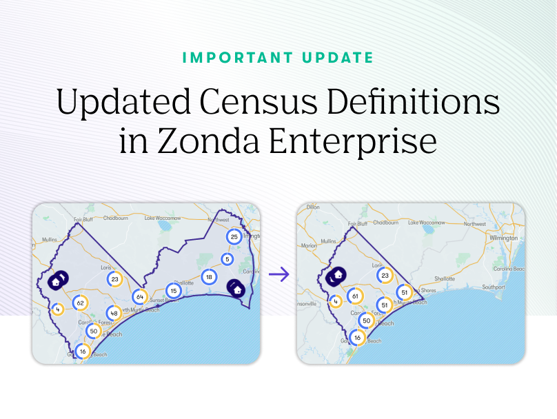
E.g., Brunswick County moved from Myrtle Beach-Conway-North Myrtle Beach, SC CBSA to the Wilmington, DE CBSA.

If Myrtle Beach is selected in Geography Selection/Active Boundaries, the results in the map, table, and exports will no longer include Brunswick County. Any exports that include historical data will be based upon the new delineation, and will no longer include Brunswick County. It will be as though Myrtle Beach has always been this way historically. If a CBSA has lost counties, simply add the CBSA and the removed counties separately into your Active Boundaries so get results.

E.g., Brunswick County moved from Myrtle Beach-Conway-North Myrtle Beach, SC CBSA to the Wilmington, DE CBSA.
If Myrtle Beach is selected in Geography Selection/Active Boundaries, all Data Summaries and Market Reports will no longer include Brunswick County. Any historical aspects of the reports will be based upon the new delineation, and will no longer include Brunswick County. It will be as though Myrtle Beach has always been this way historically.
One exception to the update is the state of Connecticut. Connecticut transitioned from using counties for administrative purposes to planning regions in 2022. While Connecticut’s eight counties still exist in name, they no longer serve as governmental entities. Instead, the state now recognizes nine Councils of Governments (COGs) as the primary regional governance structure. These planning regions are used for municipal cooperation, regional planning, and state-level resource allocation.
Enterprise will continue using the eight counties in Connecticut for the foreseeable future, until other data sources on which it depends are updated.
Click here for more detailed information